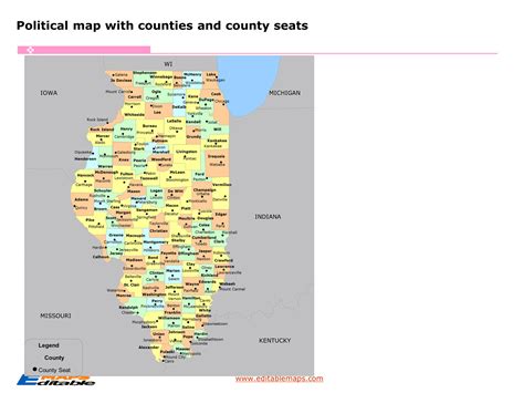
Illinois Counties Map

Located in the Midwestern United States, Illinois is a state with a diverse geography and a rich history. The state is divided into 102 counties, each with its unique characteristics, attractions, and contributions to the state's economy and culture. Understanding the Illinois counties map is essential for navigating the state, whether for business, tourism, or educational purposes. In this article, we will delve into the specifics of the Illinois counties map, exploring their historical backgrounds, geographical features, and economic significance.
Key Points
- Illinois is divided into 102 counties, with Cook County being the most populous.
- The counties vary significantly in size, population, and economic activities.
- Understanding the Illinois counties map is crucial for navigating the state's diverse regions.
- The state's geography ranges from urban areas like Chicago to rural landscapes and natural reserves.
- Economically, Illinois counties are involved in various sectors, including agriculture, manufacturing, and services.
Historical Background of Illinois Counties

The formation of Illinois counties dates back to the early 19th century, with the state’s admission to the Union in 1818. Initially, the state was divided into a few large counties, which were later subdivided into smaller ones as the population grew and the need for more localized governance increased. The naming of the counties often reflects the state’s history, with many named after early settlers, politicians, and military figures. For example, Cook County, the most populous county and home to Chicago, was named after Daniel Pope Cook, a politician who played a significant role in the state’s early development.
Geographical Features and Regional Divisions
Illinois can be broadly divided into several geographical regions, each with its unique features and characteristics. The northern part of the state is largely urban, with the Chicago metropolitan area dominating the landscape. This region is not only the economic hub of the state but also a center for culture, education, and innovation. In contrast, the southern part of Illinois is more rural, with a stronger emphasis on agriculture and natural resources. The central and western parts of the state offer a mix of urban and rural landscapes, with cities like Springfield and Peoria serving as regional centers.
| Region | Description | Counties |
|---|---|---|
| Northern Illinois | Urban, economic hub | Cook, DuPage, Kane |
| Southern Illinois | Rural, agricultural | Jackson, Williamson, Union |
| Central Illinois | Mixed urban and rural | Sangamon, Peoria, Tazewell |
| Western Illinois | Rural, natural resources | Adams, Hancock, McDonough |

Economic Significance and Diverse Activities

The economy of Illinois is as diverse as its geography, with different counties specializing in various sectors. Agriculture is a significant contributor, especially in the rural areas, with Illinois being a leading producer of corn, soybeans, and other crops. The state is also home to a robust manufacturing sector, with industries ranging from food processing to heavy machinery. The services sector, including finance, healthcare, and education, plays a vital role, particularly in the urban areas. Tourism is another important sector, with attractions like Chicago’s Willis Tower, the Illinois and Michigan Canal, and the Shawnee National Forest drawing visitors from all over the world.
County Profiles: Examples of Diversity
To illustrate the diversity among Illinois counties, consider the examples of Cook County and Jackson County. Cook County, with its urban landscape and international influence, offers a cosmopolitan experience with world-class museums, theaters, and restaurants. In contrast, Jackson County in southern Illinois provides a glimpse into the state’s rural heritage, with its rolling hills, scenic lakes, and historic sites like the Shawnee National Forest. Each county has its unique charm and attractions, making Illinois a fascinating state to explore.
What is the most populous county in Illinois?
+Cook County is the most populous county in Illinois, with the city of Chicago being its county seat.
How many counties are there in Illinois?
+There are 102 counties in the state of Illinois.
What are the main economic sectors in Illinois?
+The main economic sectors in Illinois include agriculture, manufacturing, and services, with tourism also playing a significant role.
In conclusion, the Illinois counties map presents a complex and fascinating picture of diversity and unity. From the bustling streets of Chicago to the quiet landscapes of rural Illinois, each county contributes its unique character to the state’s rich tapestry. Understanding this diversity is not only essential for navigating the state’s geography but also for appreciating its history, economy, and cultural heritage. Whether you are a resident, a visitor, or simply interested in learning more about Illinois, exploring its counties is a journey worth taking.


